Hidrografi
Maritime Boundaries and the Exclusive Economic Zone: How Survey Data Draws the Line
A country's maritime territory is not fixed by a treaty signature alone — it is measured outward, nautical mile by nautical mile, from a line that a hydrographic surveyor first had to establish on the water. That line, called the baseline, is the single reference point from which territorial sea, exclusive economic zone (EEZ), and continental shelf claims are all calculated under the United Nations Convention on the Law of the Sea (UNCLOS). Get the baseline wrong, or leave it undefined, and every zone measured from it is wrong too.

What a Baseline Actually Measures From
Under UNCLOS Article 5, the "normal baseline" is the low-water line along the coast, as shown on large-scale charts officially recognised by the coastal state — which is precisely why it has to be surveyed and charted before it can be legally used, not simply drawn from a satellite image or an old map. Coastlines that are deeply indented, fringed with islands, or otherwise irregular can instead use straight baselines under Article 7, connecting selected points along the coast. Archipelagic states go a step further: Article 47 lets them draw straight archipelagic baselines connecting the outermost points of their outermost islands, treating the entire island group as a single unit for the purpose of measuring every zone that follows.
The Zones That Stack Outward From It
From the baseline outward, UNCLOS defines a sequence of zones, each with a different limit and a different bundle of rights. The territorial sea extends 12 nautical miles, and within it the coastal state holds full sovereignty over the water column, seabed, subsoil, and airspace — legally almost equivalent to land territory. The contiguous zone extends a further 12 nautical miles, to 24 nautical miles total, where Article 33 allows the state to enforce customs, immigration, fiscal, and sanitary laws without holding full sovereignty over the water itself. The exclusive economic zone reaches out to 200 nautical miles, granting the coastal state sovereign rights over living and non-living resources — fish stocks, oil, gas, seabed minerals — while leaving the surface waters open to international navigation and overflight. The continental shelf, by default, also extends to 200 nautical miles regardless of the seafloor's actual geological shape, giving the coastal state rights over seabed and subsoil resources specifically.
When the Seafloor Extends the Claim Beyond 200 Nautical Miles
Article 76 allows a coastal state to claim continental shelf rights beyond 200 nautical miles if it can show the seabed is a natural geological extension of its landmass — but that claim has to be substantiated with actual seismic, bathymetric, and sediment-thickness data, not asserted by distance alone. The outer limit is fixed using two families of lines defined in the IHO/IAG/IOC technical manual on UNCLOS (TALOS): "formula lines" (the Gardiner and Hedberg lines, derived from sediment thickness and distance from the foot of the continental slope) and "constraint lines" (a hard cap of either 350 nautical miles from the baseline, or 100 nautical miles beyond the 2,500-metre depth contour). The state's proposed limit is the inner envelope of whichever formula and constraint lines apply — meaning the seafloor data itself, not the state's preference, decides where the line can legally sit. Every submission is reviewed by the Commission on the Limits of the Continental Shelf (CLCS), a 21-member body of experts in geology, geophysics, and hydrography who scrutinise the adequacy of the data before recommending an outer limit.
Case in Point: Indonesia's Own Baseline Survey
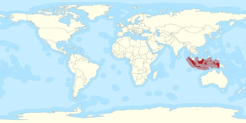
As an archipelagic state, Indonesia's entire maritime claim rests on a straight archipelagic baseline system connecting basepoints across its outer islands — a system that had to be surveyed, not assumed. The baseline coordinates now in force were originally established through a survey carried out by Pushidros TNI AL (the Indonesian Navy's Hydro-Oceanographic Centre) and formalised in Government Regulation No. 38 of 2002, later revised by Government Regulation No. 37 of 2008 to account for subsequent boundary developments, including an International Court of Justice ruling affecting Indonesia's eastern basepoints. The resulting system runs to roughly 8,167.6 nautical miles across 196 segments and 183 basepoints, enclosing an estimated 666,000 square nautical miles of archipelagic waters — a scale of claim that is only as legally sound as the survey work underpinning each basepoint.
Case in Point: Turning Survey Data into 4,209 Additional Square Kilometres
In June 2008, Indonesia submitted a partial claim to the CLCS for an extended continental shelf beyond 200 nautical miles northwest of Sumatra — one of the country's first tests of the Article 76 process. The submission had to demonstrate, with seismic and bathymetric survey data, that the seabed there was a natural prolongation of the Sumatran landmass rather than simply open ocean floor. The Commission's recommendations, issued in March 2011, confirmed Indonesia's entitlement to roughly 4,209 square kilometres of additional continental shelf beyond what the standard 200-nautical-mile limit would have allowed — seabed that Indonesia can now manage for resource purposes purely because its scientific and technical submission held up under CLCS review.
When Two Coastlines Overlap: Delimitation and the Bay of Bengal
Establishing a state's own outer limit is only half the picture — where two coastlines are close enough that their claimed zones overlap, the boundary between them has to be delimited, and states do not always agree on where that line should fall. Bangladesh and Myanmar took their overlapping Bay of Bengal claims to the International Tribunal for the Law of the Sea (ITLOS), which registered the case in December 2009, heard oral arguments in Hamburg in September 2011, and delivered its judgment on 14 March 2012. It was the first maritime boundary case ever brought before ITLOS, and its ruling — which delimited the territorial sea, EEZ, and continental shelf boundaries between the two states — marked the first time a judicial body had delimited a continental shelf boundary beyond 200 nautical miles, rather than leaving that question to a separate CLCS process.
Why This Matters Beyond the Courtroom
Cases like Bangladesh/Myanmar exist because overlapping claims are common, not exceptional, wherever coastlines sit less than 400 nautical miles apart. Whether a dispute is resolved by negotiation or by a tribunal, the underlying argument on both sides is built from the same kind of material: charted baselines, bathymetric data, and geomorphological evidence of where the seabed actually lies — the same categories of survey data discussed throughout this section, just turned toward a legal rather than an engineering question.
Why the Surveyor's Line Matters More Than the Cartographer's
It is easy to think of maritime boundaries as a matter for diplomats and international lawyers, and in the negotiating room, they are. But every one of those negotiations starts from a number — a distance in nautical miles, measured from a baseline that someone had to survey, chart, and get officially recognised first. Indonesia's own archipelagic system, its extended shelf claim off Sumatra, and international rulings like Bangladesh/Myanmar all trace back to the same starting point: hydrographic survey data that is precise enough, and defensible enough, to hold up as evidence of where a nation's territory actually begins and ends.
References
- United Nations, "United Nations Convention on the Law of the Sea, Part II — Territorial Sea and Contiguous Zone," https://www.un.org/depts/los/convention_agreements/texts/unclos/part2.htm
- National Oceanic and Atmospheric Administration (NOAA), "Maritime Zones and Boundaries," https://www.noaa.gov/maritime-zones-and-boundaries
- International Hydrographic Organization (IHO), International Association of Geodesy (IAG), Intergovernmental Oceanographic Commission (IOC), "A Manual on Technical Aspects of the United Nations Convention on the Law of the Sea (TALOS)," https://iho.int/uploads/user/pubs/cb/c-51/C_51_Ed600_052020.pdf
- Patmasari, R., "The Indonesian Archipelagic Baselines," IHO Advisory Board on the Law of the Sea (ABLOS) Conference 5, https://legacy.iho.int/mtg_docs/com_wg/ABLOS/ABLOS_Conf5/Presentations/Session6-Presentation2-Patmasari.pdf
- U.S. Department of State, "Limits in the Seas No. 141 – Indonesia," https://www.state.gov/wp-content/uploads/2020/02/LIS-141.pdf
- Sutisna, S. and Lokita, S., "Indonesian First Experiences in Delineating Extended Continental Shelf Submission to the UN CLCS," Indonesian Journal of International Law, https://scholarhub.ui.ac.id/ijil/vol8/iss4/5/
- International Tribunal for the Law of the Sea (ITLOS), "Dispute Concerning Delimitation of the Maritime Boundary between Bangladesh and Myanmar in the Bay of Bengal," Case No. 16, https://www.itlos.org/index.php?id=108
Related Articles