Geofisika & Geohazard
Seismic Refraction Survey: Reading Bedrock Depth Before You Design the Foundation
Seismic reflection, already covered elsewhere on this site, is built to map layers — where one sediment package ends and another begins. Seismic refraction asks a different question entirely: not where the boundaries are, but how stiff, how fast, and how deep the rock beneath them actually is. For a foundation engineer, that second question is often the one that decides whether a structure sits on ordinary soil or has to be piled straight down to bedrock.
The Physics: Critical Refraction, Not Reflection
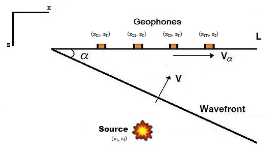
Both methods send seismic energy into the ground from a source and record the return with an array of receivers, but they read different arrivals. Reflection reads energy that bounces back off a boundary where acoustic impedance changes. Refraction reads energy that travels along a boundary at a specific critical angle — governed by Snell's Law — and re-emerges to the surface ahead of the direct wave once it has travelled far enough. Because that critically refracted arrival only exists where each deeper layer is faster than the one above it, refraction surveys only work cleanly where seismic velocity increases with depth, which is the normal case for soil sitting above bedrock but not guaranteed in every geological setting.
What the Survey Actually Delivers
The output of a refraction survey is a velocity model of the subsurface, built from the travel times recorded at each geophone: compressional wave velocity (Vp), and — through a related technique called Multichannel Analysis of Surface Waves (MASW) run off the same or a companion dataset — shear wave velocity (Vs). Because a material's shear-wave velocity tracks closely with its stiffness, Vs30 (the average shear wave velocity through the top 30 metres) has become a standard input for evaluating how a site will respond to seismic shaking, alongside the more basic deliverable every foundation designer wants first: depth to bedrock, without having to drill a borehole at every point along a site.
Taking Refraction Offshore
Offshore, refraction is typically run as Continuous Marine Seismic Refraction (CMSR): a small-volume airgun towed behind a vessel alongside a multichannel streamer, commonly deployed with around 32 channels spaced roughly 1.5 to 6 metres apart across a 100-metre array, with records acquired every 5 to 7 metres along the survey line. Typical investigation depth runs 20 to 40 metres below the seabed, depending on the velocity contrast present at the site.
Where CMSR Outperforms Sub-Bottom Profiling
Sub-bottom profiling (SBP), a single-channel reflection technique, is the default tool for shallow marine stratigraphy, but comparative surveys on coastal geotechnical projects have shown two conditions where CMSR's velocity data adds something SBP alone cannot. In one case, over steeply dipping metamorphic bedrock beneath variable intertidal and marine sediments, SBP could mark a minimum depth to hard basement but couldn't reliably tell whether that reflector was the true sediment-bedrock boundary or just a change in weathering — while CMSR's compressional velocity profile, using a roughly 2,000 metres-per-second contour as the practical marker, gave a clearer geological read. In a second case, in low-velocity calcareous sedimentary ground, SBP performed well offshore but lost the target reflector in shallow clutter near the shoreline, where shallow water and coarse sediment interference degraded the reflection image — conditions under which the CMSR velocity profile kept delivering usable rock-property data right up to the coast.
Case in Point: Sizing Foundations for the Taiwan Strait
Offshore wind foundation design in Taiwan's Changhua and Chang-Bin project areas depended on knowing exactly this kind of depth-to-bedrock answer. Site investigations there combined four marine seismic techniques — high-resolution multichannel seismic reflection, sparker seismic, boomer, and chirp sub-bottom profiling — together with borehole and P-wave/S-wave logging data, to build a three-dimensional ground model of the strait's subsurface. The results placed the engineering bedrock, defined as the depth at which the 30-metre average shear wave velocity (Vsd30) exceeds 360 metres per second, at 49.5 to 83 metres below the seabed depending on location. Based on those findings, the recommendation for future ground-response analysis of foundation seismic demand in the area was to drill more than 100 metres below the seabed — a target depth that would have been guesswork without the velocity data the seismic survey had already provided.
Why the Velocity Number Comes First
A foundation designer doesn't ultimately need a picture of the seabed's layers — they need a defensible number for how deep competent bedrock actually sits and how stiff it is once you reach it. Reflection surveys, backscatter classification, and sub-bottom profiling all contribute to that picture in their own way, but refraction is the method built specifically to answer the depth-and-stiffness question directly, from the surface, before a single borehole confirms it.
References
- U.S. EPA, "Seismic Refraction," https://www.epa.gov/environmental-geophysics/seismic-refraction
- RETTEW, "Seismic Refraction vs Reflection," https://www.rettew.com/services/geophysics/seismic-refraction-vs-reflection/
- "Comparing Sub Bottom Profiling and Seismic Refraction Tomography Results and Interpretations for Coastal Marine Geotechnical Projects," Fast Times Online, https://fasttimesonline.co/comparing-sub-bottom-profiling-and-seismic-refraction-tomography-results-and-interpretations-for-coastal-marine-geotechnical-projects/
- "Site-Specific Shear Wave Velocity Investigation for Geotechnical Engineering Applications Using Seismic Refraction and 2D Multi-Channel Analysis of Surface Waves," ScienceDirect, https://www.sciencedirect.com/science/article/pii/S2090997713000291
- "A Methodology for Estimating the Position of the Engineering Bedrock for Offshore Wind Farm Seismic Demand in Taiwan," Energies (MDPI), https://doi.org/10.3390/en14092474
- U.S. Geological Survey, "Seismic Site Characterization with Shear Wave (SH) Reflection and Refraction Methods," https://www.usgs.gov/publications/seismic-site-characterization-shear-wave-sh-reflection-and-refraction-methods
Related Articles
Multichannel Seismic Reflection in Practice: The Coelacanth Discovery in the Gulf of Mexico
Marine Geotechnical Investigation: A Case Study in CPT and Vibrocore Sampling for Offshore Wind Foundations